

Tornadoes Tear Through the Plains as Blizzards Sweeps Across Central US
A spring storm has unleashed tornadoes across the Plains and the South and brought blizzard conditions to the central and Midwest U.S., beginning over the weekend and expected to persist till Tuesday. Tornado warnings are still in effect for Texas, Louisiana, and Arkansas in response to the severe conditions, which also pose threats of large hail and wind gusts reaching up to 70 mph.
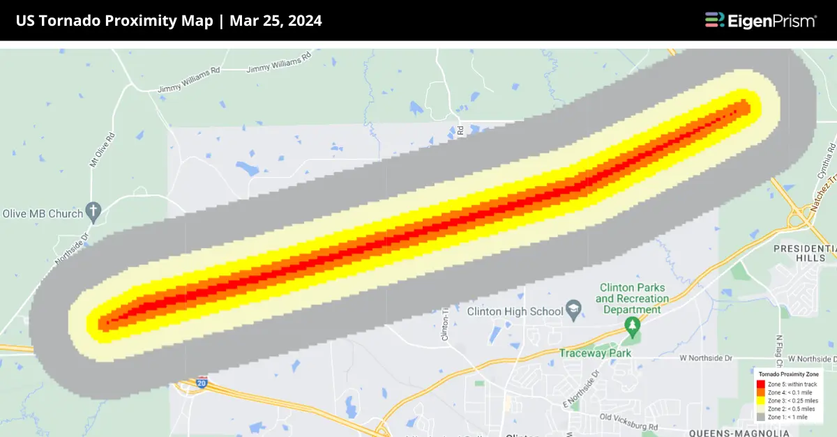
On Monday, a tornado watch was in effect across these states until around 8:00 p.m. Central Time, covering 9 million people in the Lower Mississippi Valley, particularly in Louisiana and Mississippi. Canopy Weather confirmed a tornado on Monday near Jackson, moving towards Presidential Hills in Mississippi.
On Sunday, the storm unleashed five tornadoes, with three in Kansas and two in Texas making headlines. As the National Weather Service reported, one tornado in Perryton, Texas, inflicted significant damage on Ochiltree General Hospital’s roof. Following this, Perryton faces a winter weather advisory, predicting 1-2 inches of snow on Tuesday, which complicates the efforts to assess the tornado’s impact and strength.
Another tornado on Sunday in Garden City, Kansas, damaged a power line, along with plenty of roofs and fences. As the storm advances into East Texas and heads towards Louisiana and Mississippi by Tuesday, it is poised to intensify, raising concerns over damaging winds, potential strong tornadoes, large hail, and flash flooding.
This severe weather threat coincides with the anniversary of the deadly tornado that struck Rolling Fork, Mississippi, on March 24, 2023. That tornado resulted in 25 fatalities, injured 55 people, and led to the destruction of approximately 2,000 homes, according to the Federal Emergency Management Agency.
Furthermore, over 12 million individuals across 13 states from New Mexico to Michigan are under winter weather alerts, including blizzard warnings for Nebraska and parts of Colorado, Kansas, South Dakota, and Minnesota.
Tornadoes and Blizzard Conditions Ravage Central US: Actionable Insights on EigenPrism
Post-event
Subscribers of Canopy Weather can assess the impact of the tornadoes from Mar 25 – Mar 26, 2024, using this report template within EigenPrism®
US Tornadoes Mar 24 – 25, 2024 Canopy Weather Impact Summary
All EigenPrism® users can assess the post-event impact of tornadoes and hail using the following report template:
US Severe Weather Mar 24 – 25, 2024
The report template auto-updates with the latest available footprints, which include:
- EF1 Garden City Tornado track
- EF1 Northwest Shamrock Tornado track
- EF1 Perryton South Tornado track
- EF0 Ochiltree Hospital Tornado track
- 24-Hr Hail Swath ending 2024-03-25
- 24-Hr Hail Swath ending 2024-03-26
Forecast
All EigenPrism® users can assess the forecast of this multi-peril event using the following report templates:
US Severe Weather Mar Forecast Report
The report template auto-updates with the latest available forecasts, which include:
- Significant Tornado Day 1 Outlook
- NA 5-day Flood Potential
- NA 3-day Flood Potential
- 72-Hr Forecast Snow Accumulation
- 1-3 Day Potential Winter Storm Overall Impact
Escape the News Cycle | Get Alerts Automatically For Events Impacting Your Assets
With EigenPrism Alerts, you can set Alerts and free yourself from constant event monitoring. Set up personalized alerts based on predefined impact thresholds and choose how you receive them – via email, SMS, or directly within EigenPrism. This way, you stay informed on your own terms, focusing only on the events that truly matter to your assets.
Set your alerts now.
Don’t have access to EigenPrism®?
Sign up for a trial account and access full impact reports of all events. Contact us, and we’ll set up a trial account for you.


