

Tornadoes and Strong Storms Ravage Southeast US, Leaving Extensive Damage
On Friday night, strong storms and ten confirmed tornadoes in the Southeast US tore off roofs, completely destroyed some neighborhoods, and knocked out electricity for thousands of people. At least 26 people have been killed and hundreds injured.
Over the course of Friday night, an EF-4 tornado destroyed much of the village of Rolling Fork as the community experienced winds as high as 170 miles per hour. As of Saturday afternoon, more than 32,000 homes and businesses in Mississippi, Alabama, and Tennessee lacked electricity.
When the storm moves off the East Coast by Saturday evening, the major dangers will be strong winds, hail, and isolated tornadoes. Severe storms could affect more than 20 million people in large sections of the Midwest and the South on Monday. The primary risks throughout the day are expected to be large hail, damaging wind gusts, and frequent lightning, although isolated tornadoes could still be possible.
Assessing the Impact
To make timely decisions concerning these events, EigenPrism® users can use following quick links:
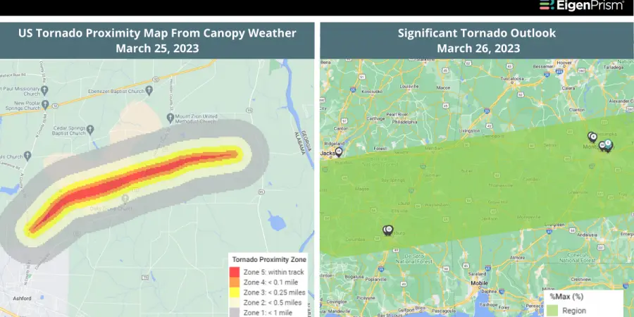
- Significant Tornado Outlook as of 2023-03-26
- EF1 Union County Tornado track on 2023-03-26
- 24-hr Tornado Reports ending 2023-03-25
- Tornado MS Sharkey County as of 2023-03-25
- Significant Hail Outlook as of 2023-03-26
- Significant Wind Outlook as of 2023-03-25
For subscribers of Canopy Weather, real-time footprints within EigenPrism® are now available for analysis:
- US Tornado proximity map for Mar 25, 2023
March 24, 2023 | Flood and Tornado Threat From Mississippi to Ohio as Severe Storm System Approaches
On Friday, a powerful storm system is forecast to impact around 30 million people, from the lower Mississippi Valley to the lower Ohio Valley. Moreover, The Storm Prediction Center has issued a warning that a tornado outbreak is probable on Friday night in several areas of the Mid-Mississippi Valley. Strong tornadoes are most likely to strike populous cities like Shreveport, Louisiana; Little Rock, Arkansas; Memphis, Tennessee; and Jackson, Mississippi, which together have nearly six million residents.
Dallas Fort Worth International Airport was forced to suspend operations on Friday morning due to a tornado warning in western Texas. So far, the storm’s worst effects have been felt near the border between Oklahoma and Missouri, where some regions received between 1 and 3 inches of rain, prompting flash flood warnings.
Overnight, these same areas could receive another 1 to 3 inches of rainfall. The storm may generate strong to severe (EF-3+) tornadoes, with long-track tornadoes also a possibility. On Friday and overnight, damaging winds with gusts exceeding 75 mph and hail are likely.
Assessing the Impact
To make timely decisions concerning these events, EigenPrism® users can use following quick links:
- Significant Tornado Outlook as of 2023-03-24
- Significant Hail Outlook as of 2023-03-24
- Significant Wind Outlook as of 2023-03-24
- NA 5-day Flood Potential as of 2023-03-23
- WPC 3-Day Excessive Rainfall Outlook valid from 2023-03-24 to 2023-03-27
Don’t have access to EigenPrism®?
Sign up for a trial account and
access full impact reports of all events. Contact us and we’ll set up a trial account for you.


