

Severe Weather Unleashes Tornadoes and Flash Floods Across the South US
On Thursday night, significant flooding occurred in West Virginia and Pennsylvania due to storms that brought heavy rainfall, flooding streets and inundating homes and businesses. These storms were part of a more extensive weather system that had previously affected Florida, causing destructive tornadoes, extensive flooding, and power outages across the Gulf Coast. A tornado in St. Augustine, Florida, caused significant damage over a 2 to 2.5-mile stretch in the TrailMark area. Another tornado was also reported north of Tampa that afternoon during ongoing coastal thunderstorms.
Flash flood warnings were issued across western parts of West Virginia and Pennsylvania, including Pittsburgh, where rainfall significantly exceeded monthly averages. Pittsburgh received 7.09 inches since Wednesday night, more than double the typical rainfall for April. The storm system has also caused substantial power outages, leaving nearly 120,000 people without electricity in the East, with significant outages in West Virginia, North Carolina, and Virginia.
Louisiana, severely affected by Wednesday’s storms, still reported 20,000 without power. Damage assessments from Wednesday include at least five tornadoes across Louisiana, Texas, and Alabama. In Lake Charles, Louisiana, a tornado with winds reaching 115 mph caused severe damage to roofs and power lines. Similarly, Port Arthur, Texas, saw an EF-2 tornado that traveled over 2 miles, uprooting trees and damaging homes.
Significant street flooding occurred in New Orleans on Wednesday, prompting the issuance of a flash flood emergency. Additionally, life-threatening flash floods struck the Tallahassee, Florida, area on Thursday, with water entering buildings and necessitating rescue operations. Although the severe weather threat is diminishing, strong winds continue to affect the region, with over 30 million people under wind advisories.
Severe Weather Unleashes Tornadoes and Flash Floods Across the South US: Actionable Insights on EigenPrism
Post-Event
Flood
Subscribers of ICEYE can use this real-time footprint on EigenPrism® to quickly assess the impact of flooding:
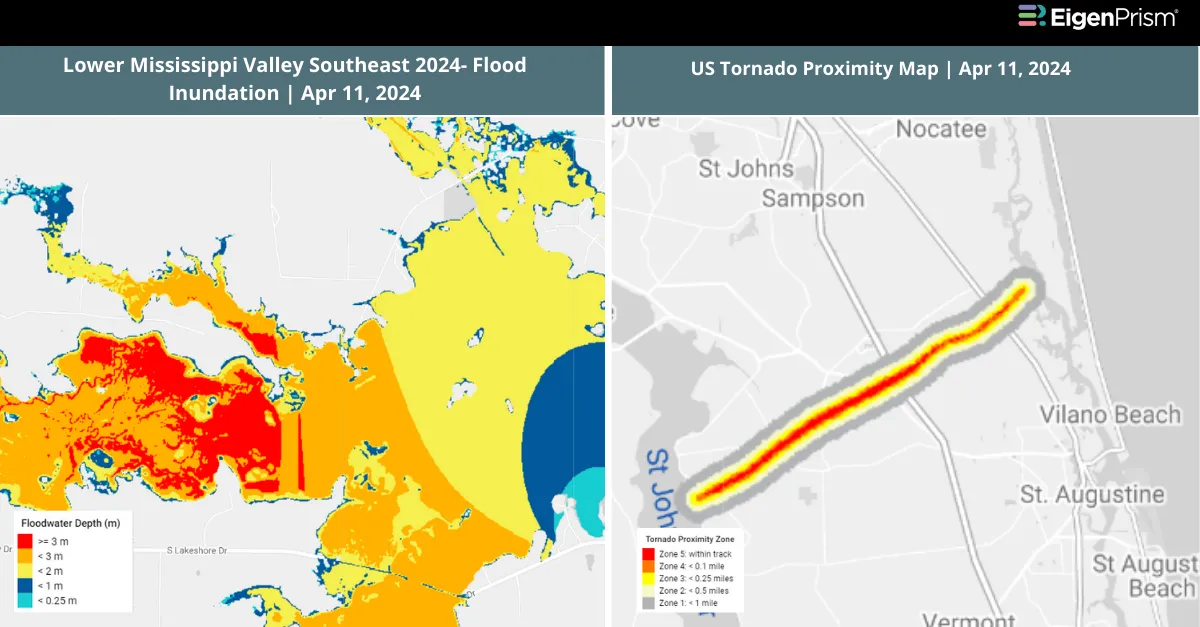
Flash Flood – Lower Mississippi Valley Southeast 2024- Flood Inundation as of 2024-04-11
Tornado & Hail
Subscribers of Canopy Weather can assess the impact of the tornadoes from Apr 10 – Apr 11, 2024, using this report template within EigenPrism®
US Tornadoes Apr 10 – 11, 2024 Canopy Weather Impact Summary
All EigenPrism® users can assess the post-event impact of tornadoes and hail using the following report template:
US Severe Weather Apr 10 – 11, 2024 Post-Event Impact
The report template contains the latest available footprints, which include:
- EF2 near Lake Charles Tornado Track
- EF2 Slidwell Tornado Track
- EF2 near Lakeview Tornado Track
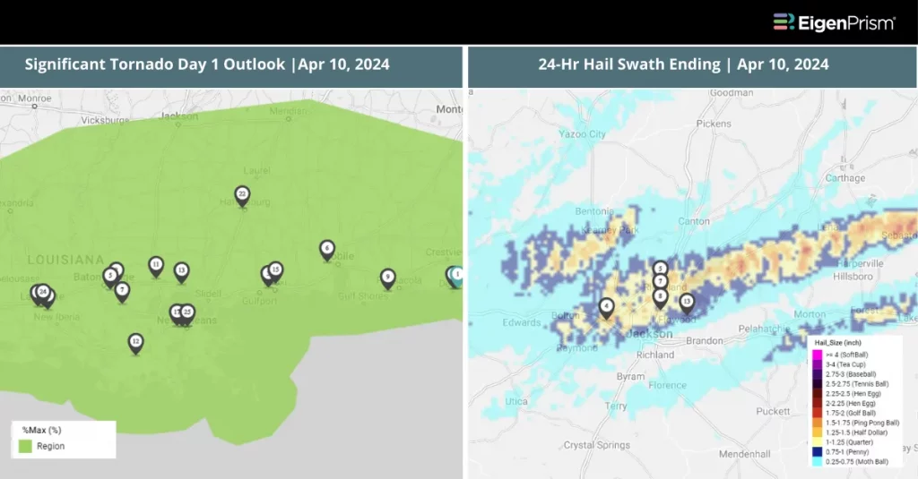
- 24-Hr Hail Swath ending 2024-04-11
- 24-Hr Hail Swath ending 2024-04-10
Forecast
The report template auto-updates with the latest available forecasts, which include:
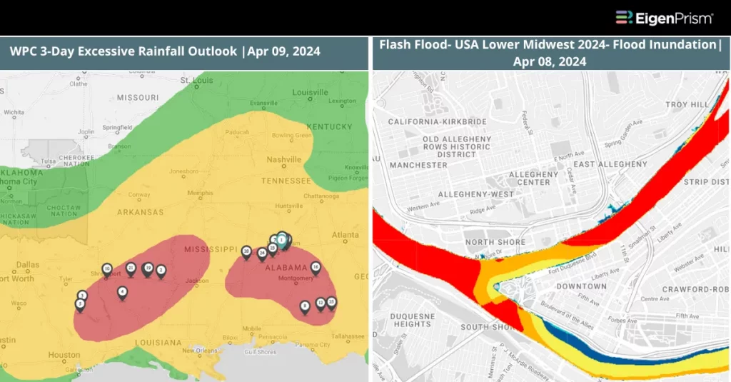
- WPC 3-Day Excessive Rainfall Outlook
- US Flood Outlook
- NA 5-day Flood Potential
- NA 3-day Flood Potential
Apr 10 | Severe Weather Moves Towards Southeast, After Striking Texas and Louisiana
 Parts of Texas and Louisiana experienced severe weather on Tuesday night, marking the beginning of a multi-day severe weather event across the South. Wednesday will bring more significant threats, including strong tornadoes and wind gusts exceeding 75 mph. Texas saw gusts up to 88 mph and reports of hail ranging from baseball to tennis ball-sized, especially in Austin. , wind gusts could surpass 70 mph, maintaining the threat of tornadoes.
The severe storm threat, as forecast, will shift eastward on Wednesday, impacting Louisiana, Mississippi, and Alabama with heightened risks of tornadoes and strong winds. By Thursday, the storm will spread into the Southeast, affecting Florida, Georgia, South Carolina, and North Carolina. The region faces the possibility of severe thunderstorms that could bring gusts exceeding 60 mph and hail the size of quarters.
The South is preparing for significant rainfall that could lead to life-threatening flooding, with expectations of 3-5 inches or more across different parts of the region through Thursday. Cities such as Jackson, Mississippi, and Plano, Texas, could receive up to 5 inches of rain, whereas Little Rock, Arkansas, might experience up to 8 inches.
Severe Weather Strikes Texas and Louisiana: Actionable Insights on EigenPrism
Post Event
Subscribers of Canopy Weather in EigenPrism can assess the impact of the tornadoes from April 09, 2024, using this footprint within EigenPrism®
US Tornado Proximity Map as of Apr 09, 2024
Hail
24-Hr Hail Swath ending as of 2024-04-10
Forecast
All EigenPrism® users can assess the forecast of this multi-peril event using the following report templates:
US Severe Weather April Forecast Report
The report template auto-updates with the latest available footprints, which include:
- Significant Tornado Day 1 Outlook
- Significant Hail Day 1 Outlook
The report template auto-updates with the latest available forecasts, which include:
- WPC 3-Day Excessive Rainfall Outlook
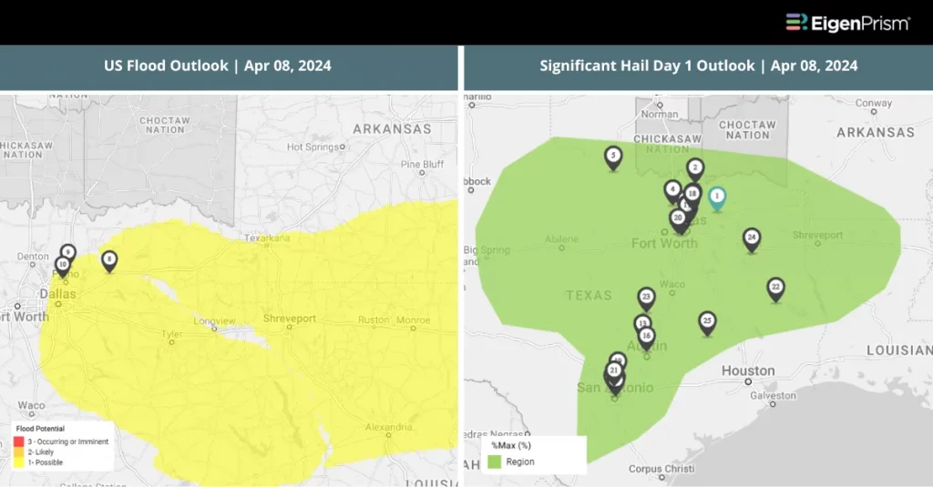
- US Flood Outlook
- NA 5-day Flood Potential
- NA 3-day Flood Potential
Apr 09 | Mississippi Valley and the South Face Risks of Flooding, Tornadoes, and Hail
 Less than a week after a powerful storm ravaged the South and Mississippi Valley, the region faces another severe weather onslaught. Starting Monday, areas stretching from Texas to Alabama are enduring heavy rain, strong winds, and dangerous thunderstorms, escalating to severe conditions on Tuesday and Wednesday. Millions face threats from heavy rainfall, large hail, and potential powerful tornadoes across the South and lower Mississippi Valley.
The Storm Prediction Center has warned for “several tornadoes, a couple of which may be strong, significant large hail, and damaging winds.” An astonishing 30 million people, spanning from Texas to western Mississippi, are in the path of these severe storms. Many of them are our neighbors, still reeling from last week’s storms and facing another weather crisis.
About 9 million people in eastern Texas and western Louisiana, including the cities of Houston and Austin, are particularly at risk, facing an “enhanced” level 3 of 5 risk for severe weather. The region is bracing for 3 to 5 inches of rain from Tuesday into Wednesday morning, with some areas potentially receiving up to 7 inches over the two days. Flood watches have been issued, starting Tuesday morning and extending into Wednesday evening. Meanwhile, in Pittsburgh, the aftermath of heavy rains that caused flooding is still being processed, and roads with high water and debris are getting cleared.
The storm threat will peak on Wednesday, marked by a moderate—level 4 out of 5—severe storm threat covering areas from eastern Louisiana to western Alabama, including Baton Rouge and Jackson. Surrounding this zone, an enhanced level 3 out of 5 threat stretches from west Louisiana to the Florida Panhandle, encompassing New Orleans and Mobile.
Mississippi Valley and the South Face Risks of Flooding, Tornadoes, and Hail: Actionable Insights on EigenPrism
Post-Event
Flood
Subscribers of ICEYE can use these real-time footprints on EigenPrism® to quickly assess the impact of flooding:
Flash Flood- USA Lower Midwest 2024- Flood Inundation as of 20240-04-08
Hail
24-Hr Hail Swath ending as of 2024-04-09
Forecast
All EigenPrism® users can assess the forecast of this multi-peril event using the following report templates:
The report template auto-updates with the latest available forecasts, which include:
- WPC 3-Day Excessive Rainfall Outlook
- US Flood Outlook
- NA 5-day Flood Potential
- NA 3-day Flood Potential
US Severe Weather April Forecast Report
The report template auto-updates with the latest available footprints, which include:
- Significant Tornado Day 1 Outlook
- Significant Hail Day 1 Outlook
Apr 08 | Severe Weather to Bring Hail and Flood Risks from Texas to Arkansas
 A severe weather outbreak threatens approximately 20 million people across Texas, Louisiana, Arkansas, and Oklahoma. Starting Monday afternoon, the region is bracing for multiple rounds of storms. Large hail poses the primary danger, with the threat shifting towards East Texas and Louisiana by Tuesday. The Texas Triangle is in the storm’s trajectory.
A Level 2 of 5 severe weather risk is in place for Monday, with Dallas facing a higher Level 3 of 5 risk. Additionally, there is a Level 2 of 4 risk for excessive rainfall extending from east of Dallas to western Mississippi. From central Texas to northern Arkansas, including Dallas, a Level 1 of 4 flood threat exists.
Flood watches will activate on Monday afternoon across parts of eastern Texas, southeastern Oklahoma, southern Arkansas, and northern Louisiana. The most intense rainfall is anticipated by Monday evening, with potential storm totals ranging between 2 and 4 inches. After that, Cleveland, Ohio, and Erie, Pennsylvania, might see morning rain with persistent scattered clouds. Southern cities face cloud concerns, severe storms, and potential flooding risks.
These storms may bring large hail, damaging winds, isolated tornadoes, and frequent lightning to the Lone Star State. On Tuesday, there’s also a risk of severe storms and flash flooding across much of Texas. Texas cities like Dallas, Kerrville, and Junction anticipate clouds at all levels, whereas Arkansas, Illinois, and Indiana, including Little Rock and Indianapolis, expect mainly high clouds.
Severe Weather to Bring Hail and Flood Risks from Texas to Arkansas: Actionable Insights on EigenPrism
All EigenPrism® users can assess the forecast of flooding using the following report template:
The report template auto-updates with the latest available forecasts, which include:
- WPC 3-Day Excessive Rainfall Outlook
- US Flood Outlook
- NA 5-day Flood Potential
- NA 3-day Flood Potential
All EigenPrism users can make use of the hail outlook from NOAA using the following link:
Significant Hail Day 1 Outlook as of 2024-04-08
Escape the News Cycle | Get Alerts Automatically For Events Impacting Your Assets
With EigenPrism Alerts, you can set Alerts and free yourself from constant event monitoring. Set up personalized alerts based on predefined impact thresholds and choose how you receive them – via email, SMS, or directly within EigenPrism. This way, you stay informed on your own terms, focusing only on the events that truly matter to your assets.
Set your alerts now.
Don’t have access to EigenPrism®?
Sign up for a trial account and access full impact reports of all events. Contact us, and we’ll set up a trial account for you.


