

Powerful Storms Sweeps Across Central to Eastern US, Bringing Potential Tornadoes and Flood Risks to the Region
An ongoing severe weather outbreak span across United States and left over 250,000 homes without power in states including West Virginia, New York, Pennsylvania, New Jersey, Ohio, Michigan, Wisconsin, Kentucky, and Georgia. Following two days of relentless heavy rain, thunderstorms, hail, and tornadoes, the storm system advanced towards the US east coast, with severe weather predicted from Florida through New England and along the northern border states.
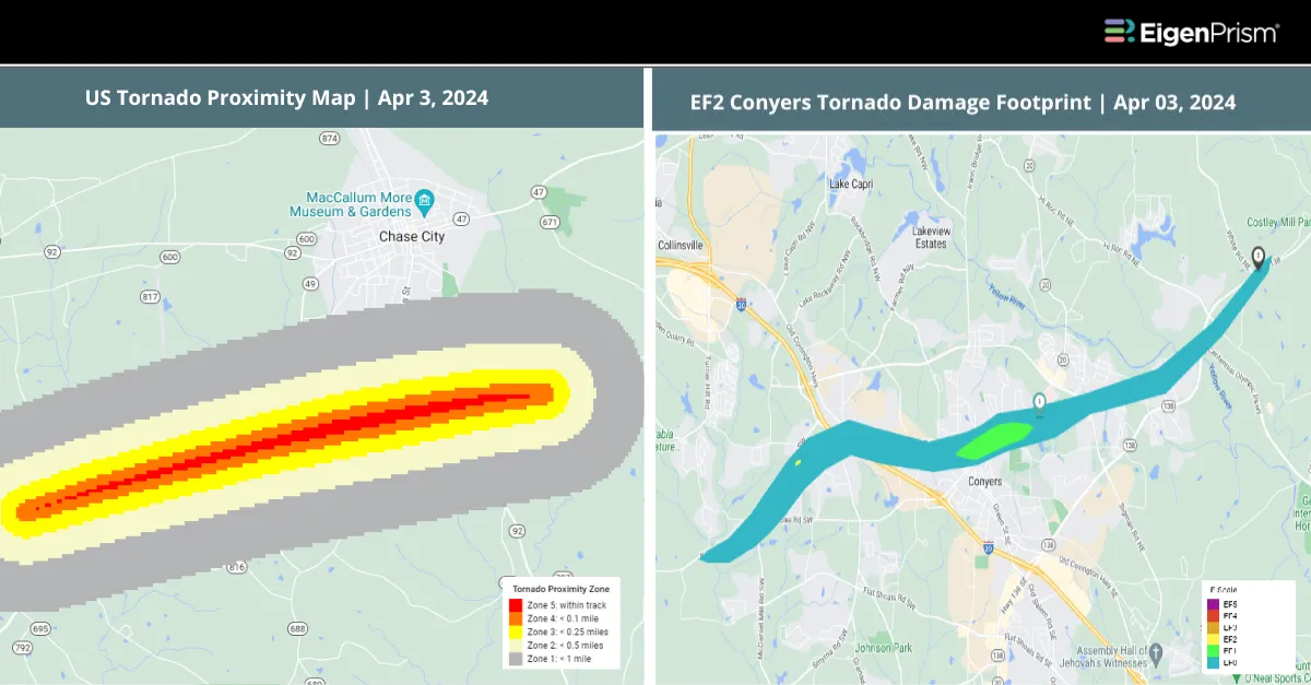
Sixteen tornadoes were reported across Illinois, Kentucky, Ohio, Alabama, Tennessee, and Georgia between Tuesday and Wednesday morning. One of them was an EF2-rated tornado in Conyers. The tornado downed power lines and caused extensive damage.
Tennessee’s Sunbright town saw damage to a funeral home and residences after a tornado hit on Tuesday. The tornado’s estimated peak wind was 105 mph, and its path length was 2.86 miles. It received an EF1 rating. Barnsdall, Oklahoma, also experienced structural damage, highlighting the widespread impact of these storms. With over 30 million people under severe weather threat from Florida to the mid-Atlantic, the Storm Prediction Center warns of the potential for more tornadoes, strong winds, and large hail.
Adding to the peril, Buffalo is under a flood watch until Thursday afternoon, with 1 to 1.5 inches of expected rainfall and possible flooding in poorly drained areas. Although severe weather is anticipated to clear in northern New York by Thursday afternoon, the forecast indicates continuing rains that may transition to snow, potentially complicating travel plans for those visiting the city for the solar eclipse on Monday.
Powerful Storms Sweeps Across Central to Eastern US: Actionable Insights on EigenPrism
Post-event
Subscribers of Canopy Weather in EigenPrism can assess the impact of the tornadoes from April 03, 2024, using this footprint within EigenPrism®
US Tornado Proximity Map as of 2024-04-03
All EigenPrism® users can assess the post-event impact of tornadoes and hail using the following report template:
US Severe Weather April 03-April 04, 2024 Post-Event Impact
The report template auto-updates with the latest available footprints, which include:
- EF2 Conyers tornado damage footprint
- EF1 Rose Road tornado track
- EF1 Plantersville tornado track
- EF0Kellyton tornado track
- EF0 Pools Crossroads tornado track
- EF0 Pools Crossroads tornado damage footprint
- 24-Hr Hail Swath Ending as of April 03, 2024
Forecast
All EigenPrism® users can assess the forecast of this multi-peril event using the following report template:
US Severe Weather April Forecast Report
The report template auto-updates with the latest available footprints, which include:
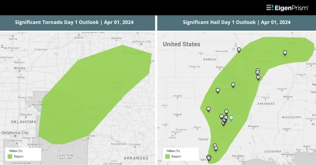
- Significant Tornado Day 1 Outlook
- Significant Hail Day 1 Outlook
- Significant Wind Day 1 Outlook
- WPC 3-Day Excessive Rainfall Outlook
- NA 5-day Flood Potential
- NA 3-day Flood Potential
April 3 | From Ohio Valley to Southeast, Severe Weather Wreaks Havoc
 The severe weather outbreak across the United States intensified, with at least nine tornadoes tearing through four states from Monday to Tuesday afternoon, impacting Oklahoma, Kentucky, Missouri, Indiana, and Illinois. West Virginia felt the wrath of the storm, with over a dozen homes damaged and more than 100,000 residents left without power. This storm brought not only damaging winds and hail but also the looming threat of tornadoes, particularly impacting the Ohio Valley region.
The Ohio River communities were among the hardest hit, with widespread damage to trees, power lines, and buildings. Evansville, Indiana, experienced an 84-mph wind gust on Tuesday morning, leading to considerable storm damage, especially on the city’s north side. Efforts to clear roads and restore power to affected areas, including traffic systems, are ongoing. A tornado watch remains in effect into the early hours of Wednesday for areas including eastern Kentucky, southeastern Ohio, southwestern Pennsylvania, and West Virginia, as stated by the National Weather Service Storm Prediction Center. In the aftermath, over 250,000 electrical outages were reported, with a significant number in West Virginia.
The threat of severe thunderstorms, encompassing tornadoes and potent wind gusts, looms large over a vast region from Columbus, Ohio, to Columbus, Georgia, including Charleston, West Virginia, Nashville, Tennessee, and Birmingham, Alabama. Additionally, flood watches stretch from Indiana to New Jersey, with cities like Indianapolis, Pittsburgh, Washington, D.C., and Philadelphia bracing for the most significant impact. Pittsburgh has already seen two to three inches of rainfall, prompting flash flood warnings.
From Ohio Valley to Southeast, Tornadoes and Storms Wreak Havoc: Actionable Insights on EigenPrism
Post-event
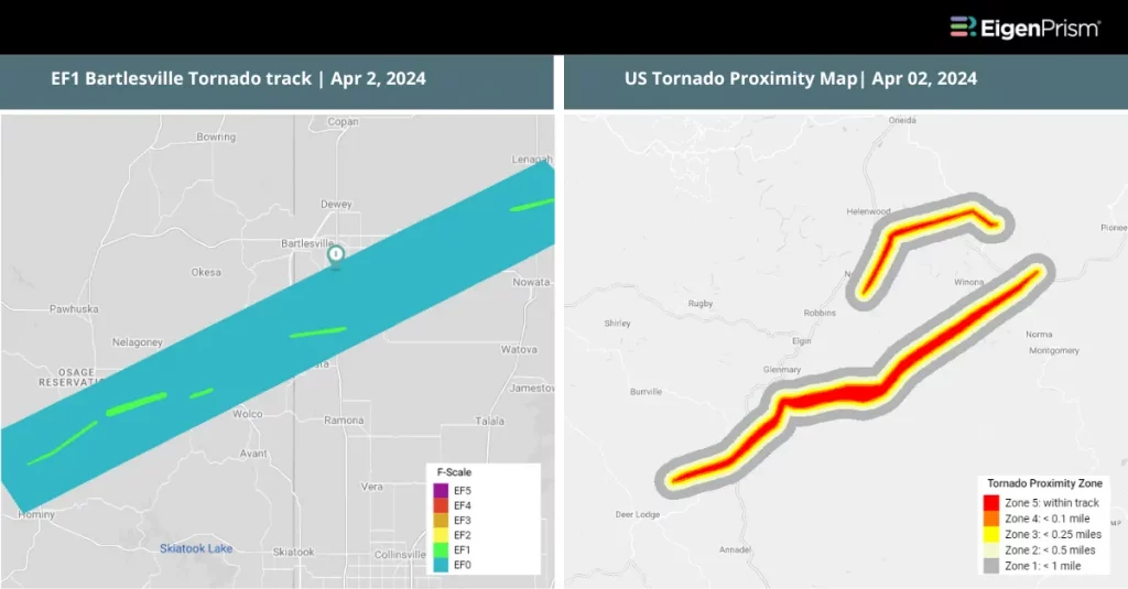
Subscribers of Canopy Weather in EigenPrism can assess the impact of the tornadoes from April 2, 2024, using this footprint within EigenPrism®
US Tornado Proximity Map as of 2024-04-02
All EigenPrism® users can assess the post-event impact of tornadoes and hail using the following report template:
US Severe Weather April 02, 2024 Post-Event Impact
The report template auto-updates with the latest available footprints, which include:
- EF0 Chesterfield Tornado Track
- EF0 Anderson Tornado Track
- EF1 Nelson County Tornado Track
- EF1 Fair Grove Tornado Track
- EF1 Anderson Tornado Track
- EF1 Bartlesville Tornado Track
- 24-Hr Hail Swath Ending as of April 02, 2024
Forecast
All EigenPrism® users can assess the forecast of this multi-peril event using the following report template:
US Severe Weather April Forecast Report
The report template auto-updates with the latest available footprints, which include:
- Significant Tornado Day 1 Outlook
- Significant Hail Day 1 Outlook
- Significant Wind Day 1 Outlook
- WPC 3-Day Excessive Rainfall Outlook
- NA 5-day Flood Potential
- NA 3-day Flood Potential
Apr 02 | Severe Weather Outbreak Intensifies, Risk Escalates Across Multiple Eastern States of the US
 The United States is currently facing a severe weather outbreak characterized by a potent mix of damaging hail, tornadoes, strong wind gusts, and flooding rains wreaking havoc across the country. On Monday evening, the storm system unleashed tornadoes, heavy rain, and tennis ball-sized hail across the central United States. The aftermath includes damaged homes, fallen trees, and disrupted power lines stretching from Texas to Kentucky.
Tornado warnings were issued on Monday for Missouri, Oklahoma, and Texas, placing over 8 million people in the path of potentially devastating tornadoes for Tuesday. The NOAA Storm Prediction Center has issued the year’s first Level 4 out of 5 risk for severe weather over central and eastern Oklahoma and far North Texas, anticipating hail up to 2-3 inches in diameter. Another Level 4 risk is centered on Ohio for Tuesday.
Reports from the National Weather Service (NWS) highlighted hail the size of hen eggs near Logan, Oklahoma, and wind-driven hail that shattered windows in Caney, Kansas. In Missouri, Chesterfield experienced golf ball-sized hail, while Nugent and Hawley, Texas, reported baseball-sized hail causing significant damage. Forecasters warn that hailstones could surpass 2 inches in diameter, with destructive winds potentially reaching up to 75 mph.
The NWS reports that near Lenapah, Oklahoma, a tornado overturned a tractor-trailer, trapping an individual inside. Additionally, another tornado was reported near the town of Hominy, Oklahoma.
On Tuesday, several states are under Tornado and Severe Thunderstorm watches. Ohio faces a high likelihood of experiencing strong tornadoes, while an enhanced risk (Level 3 out of 5) for severe storms, including tornadoes and large hail, covers a swath from Alabama to southern Pennsylvania, as per the NWS.
The severe weather risk is moving eastward into Tennessee and the Ohio River Valley, where intense rainfall may cause localized flooding. The NWS has issued flood watches effective through Tuesday for millions across the Ohio River Valley, including specific areas in Indiana, Kentucky, Ohio, West Virginia, and western Maryland. Expected rainfall could surpass two inches in many locations and reach up to five inches in certain areas.
Severe Weather Outbreak Intensifies, Risk Escalates Across Multiple Eastern States: Actionable Insights on EigenPrism
Post Event
Tornado
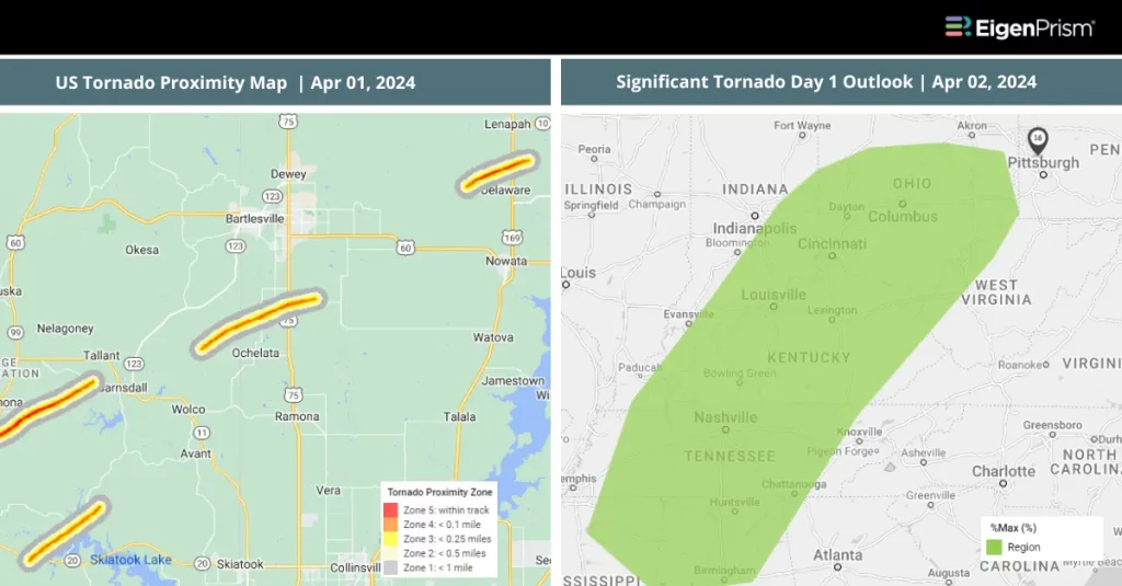
Subscribers of Canopy Weather in EigenPrism can assess the impact of the tornadoes from Apr 01 – Apr 02, 2024, using this footprint within EigenPrism®
US Tornado Proximity Map as of 2024-04-01
Note that Tornado Damage survey footprints will be available as soon as they are released by NWS.
Hail
US Hail April Post-Event Report
The report template auto-updates with the latest available footprints, which include:
- 24-Hr Hail Swath Ending 2024-04-02
- 24-Hr Hail Swath Ending 2024-04-01
Forecast
All EigenPrism® users can assess the forecast of this multi-peril event using the following report template:
US Severe Weather April Forecast Report
The report template auto-updates with the latest available footprints, which include:
- Significant Tornado Day 1 Outlook
- Significant Hail Day 1 Outlook
- Significant Wind Day 1 Outlook
- WPC 3-Day Excessive Rainfall Outlook
- NA 5-day Flood Potential
- NA 3-day Flood Potential
Apr 01 | Severe Weather Outbreak in the US, Tornado Risks Span from Dallas to DC
As April begins, the central and eastern United States brace for a severe weather outbreak. With over 53 million people in the threat zone on Monday alone, cities like Dallas, Oklahoma City, St. Louis, Indianapolis, and Cincinnati are on high alert. This event marks the start of the most active tornado season, with the potential for significant hail, damaging winds, and tornadoes through Tuesday.
A storm system from heavy rains in Southern California has fostered a new low-pressure area in the Central Plains. This system, drawing moisture from the Gulf of Mexico, will likely cause widespread thunderstorms starting Monday afternoon, extending from the southern Plains to the mid-Mississippi and Ohio valleys by evening.
Severe weather on Monday could bring huge hail and tornadoes. A corridor from North Texas to southern Illinois, including Dallas-Fort Worth and St. Louis, faces the possibility of giant hail. Central and eastern Oklahoma to south Indiana are most at risk for tornadoes.
The severe weather will continue on Tuesday, affecting 58 million people from the Ohio Valley to the mid-Atlantic and central Gulf Coast states. Wind damage and isolated large hail are forecasted, with the most significant tornado threat in Middle Tennessee through central and northern Kentucky.
Severe Weather Outbreak in the US, Tornado Risks Span from Dallas to DC: Actionable Insights on EigenPrism
All EigenPrism® users can assess the forecast of this multi-peril event using the following report template:
US Severe Weather April Forecast Report
The report template auto-updates with the latest available footprints, which include:
- Significant Tornado Day 1 Outlook
- Significant Hail Day 1 Outlook
Escape the News Cycle | Get Alerts Automatically For Events Impacting Your Assets
With EigenPrism Alerts, you can set Alerts and free yourself from constant event monitoring. Set up personalized alerts based on predefined impact thresholds and choose how you receive them – via email, SMS, or directly within EigenPrism. This way, you stay informed on your own terms, focusing only on the events that truly matter to your assets.
Set your alerts now.
Don’t have access to EigenPrism®?
Sign up for a trial account and access full impact reports of all events. Contact us, and we’ll set up a trial account for you.


