

Ex-Tropical Cyclone Megan Triggers Flooding in Northern Territory, Australia
After the impact of the ex-tropical cyclone Megan, the Northern Territory (NT) is bracing for what NT Police Commissioner Murphy has described as “a once-in-a-century” flood event.
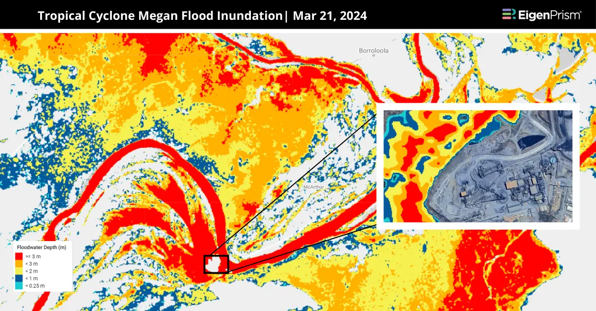
The focus of concern is the McArthur River in the community of Borroloola, where water levels will soar to staggering heights, threatening lives and properties. The McArthur River is set to hit a record 18 meters, surpassing the 2001 peak by three meters. This alarming development has forced the evacuation of over 100 people from Borroloola, a remote area already battered by the cyclone’s aftermath.
NT Police Commissioner stated that Borroloola residential zones Garuwa and Yanyula, home to 350 people, are at imminent risk of flooding. Communication issues due to tech outages have complicated the situation, disrupting coordination between Darwin’s emergency services and Borroloola.
Up to 380mm of rainfall from Monday to Wednesday contributed significantly to the flood risk. While Borroloola is currently the primary focus, the Australian Defence Force (ADF) is also on alert for other communities that may require evacuation.
A severe weather warning stretches from Tennant Creek to the Western Australian border, marking the path of ex-Tropical Cyclone Megan’s dissipation after the weekend. The forecast includes a rain band expected to bring heavy rainfall from Lajamanu to Alice Springs, with potential daily totals of about 50 millimeters—a significant amount for the central and southern parts of the Northern Territory.
Significant Flooding Risks Across Australia’s NT: Actionable Insights on EigenPrism
Post-event
Subscribers of ICEYE can use these real-time footprints on EigenPrism® to quickly assess the impact of flooding:
Tropical Cyclone Megan Flood Inundation as of 2024-03-21
All EigenPrism® users can assess the post-event impact using the following event footprints:
Australia Tropical Cyclone Megan 2024 Post-Event Impact Report
The report template auto-updates with the following latest available post-event footprints:
- Tropical Cyclone Megan 2024 Past Max Winds from NOAA
- Tropical Cyclone Megan Past Wind Swath – Advisory 12 from Hurricane Mapping
Forecast
All EigenPrism® users can assess the forecast of this flooding using the following report template:
Australia Flood Forecast Report
The report template auto-updates with the latest available forecasts, which include:
- ANZ 5-day Flood Potential from Adiabat
- ANZ 3-day Flood Potential from Adiabat
Escape the News Cycle | Get Alerts Automatically For Events Impacting Your Assets
With Alerts, you can set Alerts and free yourself from constant event monitoring. Set up personalized alerts based on predefined impact thresholds and choose how you receive them – via email, SMS, or directly within EigenPrism. This way, you stay informed on your own terms, focusing only on the events that truly matter to your assets.
Set your alerts now.
Don’t have access to EigenPrism®?
Sign up for a trial account and access full impact reports of all events. Contact us and we’ll set up a trial account for you.


