

Destructive Tornadoes Tear Through Kansas and Iowa, Causing Extensive Damage and Disruption
A potent storm system has been wreaking havoc across the Midwest and Mississippi Valley, igniting a series of powerful storms characterized by large hail, damaging winds, and tornadoes since Monday. As of Tuesday, there have been 22 reported tornadoes spanning four states—Kansas, Nebraska, Missouri, and Iowa—with the majority occurring on Tuesday, five of which had been confirmed.
According to the Wichita Weather Service, In Dallas County, Iowa, one such tornado carved a nearly 7-mile path, destroying agricultural buildings and causing minor damage to residential properties and landscapes. An EF-1 tornado with winds reaching up to 95 mph struck near Smithville, Missouri. On Tuesday, the Kansas City weather service reported that it tore off roof coverings and caused partial collapses of walls in at least one building.
By Wednesday, the storm system will move into the Ohio River Valley and the southern Great Lakes, with the most significant tornado threat poised over Michigan, Ohio, and Indiana, impacting major cities like Detroit, Indianapolis, and Cleveland. Additionally, heavy rainfall accompanying these storms could provoke flash flooding across the northern Plains and the Mississippi Valley, with rain accumulation potentially reaching up to 3 inches and hourly rates of 1 to 2 inches in certain areas. Cities like Fort Wayne, Indiana, and Milwaukee face increased risks. Numerous river gauges are already indicating minor flood stages, and further rainfall could exacerbate the situation, potentially overwhelming rivers and streams.
Destructive Tornadoes Tear Through Kansas and Iowa: Actionable Insights on EigenPrism
Post-Event
Tornado & Hail
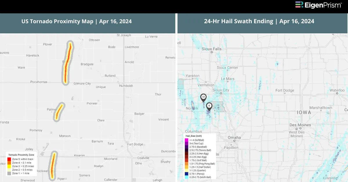
Subscribers of Canopy Weather can assess the impact of the tornadoes from Apr 16, 2024, using this report template within EigenPrism®
US Tornado Proximity Map as of 2024-04-17
All EigenPrism® users can assess the post-event impact of tornadoes and hail using the following report template:
US Severe Weather April 16, 2024 Post-Event Impact
The report template contains the latest available footprints, which include:
- EF2 Tornado Track in Greenwood
- EF1 Tornado Track near Richland
- EF1 Tornado Track in Central OS
- EF1 Tornado Track in Smithville
- 24-Hr Hail Swath ending 2024-04-16
Forecast
All EigenPrism® users can assess the forecast of this multi-peril event using the following report template:
US Severe Weather April Forecast Report
The report template auto-updates with the latest available footprints, which include:
- Significant Tornado Day 1 Outlook
- Significant Hail Day 1 Outlook
- Significant Wind Day 1 Outlook
- WPC 3-Day Excessive Rainfall Outlook
- NA 5-day Flood Potential
- NA 3-day Flood Potential
Escape the News Cycle | Get Alerts Automatically For Events Impacting Your Assets
With EigenPrism Alerts, you can set Alerts and free yourself from constant event monitoring. Set up personalized alerts based on predefined impact thresholds and choose how you receive them – via email, SMS, or directly within EigenPrism. This way, you stay informed on your own terms, focusing only on the events that truly matter to your assets.
Set your alerts now.
Don’t have access to EigenPrism®?
Sign up for a trial account and access full impact reports of all events. Contact us, and we’ll set up a trial account for you.


