

Devastating Supercell Storms Sweep Across Oklahoma and Kansas, Bringing Tornadoes, Hail, and Wind
Minden, Iowa, faced another onslaught Monday night following the severe weather outbreak of late April. According to the National Weather Service (NWS), a tornado struck just northeast of the town, damaging a house and power poles. Monday night brought a devastating supercell thunderstorm across the US, generating tornadoes, huge hailstones, and destructive winds.
In Oklahoma, the NWS issued a rare tornado emergency alert for Osage and Washington counties, highlighting the significant risk of widespread destruction and injury. In Barnsdall, the tornado impacted roughly one-third of the city, injuring several residents who required transport to hospitals in nearly 20 ambulances. The tornado ripped the roof off a local nursing home and severed power lines between Barnsdall and Bartlesville, plunging entire towns into darkness.
In Garfield County, Oklahoma, the severe weather destroyed barns, uprooted trees and caused vehicles to skid off roads and into ditches. In Kansas, storms knocked down power poles near McPherson, and softball-sized hail was seen in Dickinson. In Nebraska, high winds damaged barns near Pauline and outbuildings near Wymore.
According to the Storm Prediction Center (SPC), the severe regional weather outbreak will persist across the central and southern Plains, with south and Oklahoma, Kansas especially vulnerable to intense, long-track tornadoes. The storms will deliver hailstones between 2 and 4 inches and winds reaching 80 mph.
Early Tuesday morning, over 8 million people across Oklahoma, Kansas, Iowa, Missouri, Nebraska, and Texas remained under tornado watches. The Midwest and mid-Mississippi Valley are also bracing for thunderstorms. The Weather Prediction Center warned about potential flash flooding across the Central Plains and Middle Mississippi Valley due to heavy rainfall. Additional storms are anticipated for Wednesday, impacting regions from Texas to Ohio.
Devastating Supercell Storms Sweep Across Oklahoma and Kansas: Actionable Insights on EigenPrism
Post-Event
Tornado & Hail
Subscribers of Canopy Weather in EigenPrism can assess the impact of the tornadoes and hail from May 06, 2024, using these footprints within EigenPrism®
US Tornado Proximity Map as of 2024-05-06
Daily CONUS Hail Swath Map –as of 2024-05-06 – Prelim 3
Damage survey footprints will be available as soon they are released by NWS.
Flood
Subscribers of ICEYE can use this real-time footprint on EigenPrism® to quickly assess the impact of flooding:
Flash Flood – USA Central (USA) Kansas – Flood Inundation as of 2024-05-06
Forecast
All EigenPrism® users can assess the forecast of this multi-peril event using the following report template:
US Severe Weather 2024 Forecast Report
The report template auto-updates with the latest available footprints, which include:
- Significant Tornado Day 1 Outlook
- Significant Hail Day 1 Outlook
- Significant Wind Day 1 Outlook
- WPC 3-Day Excessive Rainfall Outlook
- NA 5-day Flood Potential
- NA 3-day Flood Potential
- US Flood Outlook
May 06 | Tornadoes and Hail Threaten Millions in the Midwest, While Texas Reels from Flooding
Over 25 million people are under threat as severe storms stretch from Dallas to Sioux Falls, South Dakota. Kansas and Oklahoma are particularly at risk, with the potential for devastating tornadoes, massive hail, and winds as strong as hurricanes hitting areas already suffering from recent deadly storms.
An elevated severe storm risk, Level 4 of 5, is set to affect over 2 million people from Oklahoma City to Wichita, Kansas. A multi-day severe weather outbreak is forecasted from Monday through Wednesday, likely increasing the already high tornado activity for the year. The Storm Prediction Center (SPC) marks a heightened risk of strong tornadoes (EF-2 or higher), particularly on Monday.
Cities such as Louisville, Nashville, Memphis, Little Rock, Cincinnati, and Indianapolis face Level 2 of 5 risks, mainly from damaging winds, although tornadoes and hail could also pose threats. Similar situations are anticipated for Wednesday, affecting areas from northeastern Texas through western Ohio. The main hazards include large hail, destructive winds, and tornadoes.
Meanwhile, from last week. Continuous rainfall has swollen rivers, flooding homes and businesses and displacing thousands. In Harris County alone, over 224 people have been rescued from homes and vehicles. With ongoing evacuation orders and flood watches, the situation remains critical as more rain targets the waterlogged Houston area, focusing on regions most at risk of excessive rainfall.
Tornadoes and Hail Threaten Millions in the Midwest, While Texas Reels from Flooding: Actionable Insights on EigenPrism
Post Event
Flood
Subscribers of ICEYE can use this real-time footprint on EigenPrism® to quickly assess the impact of flooding:
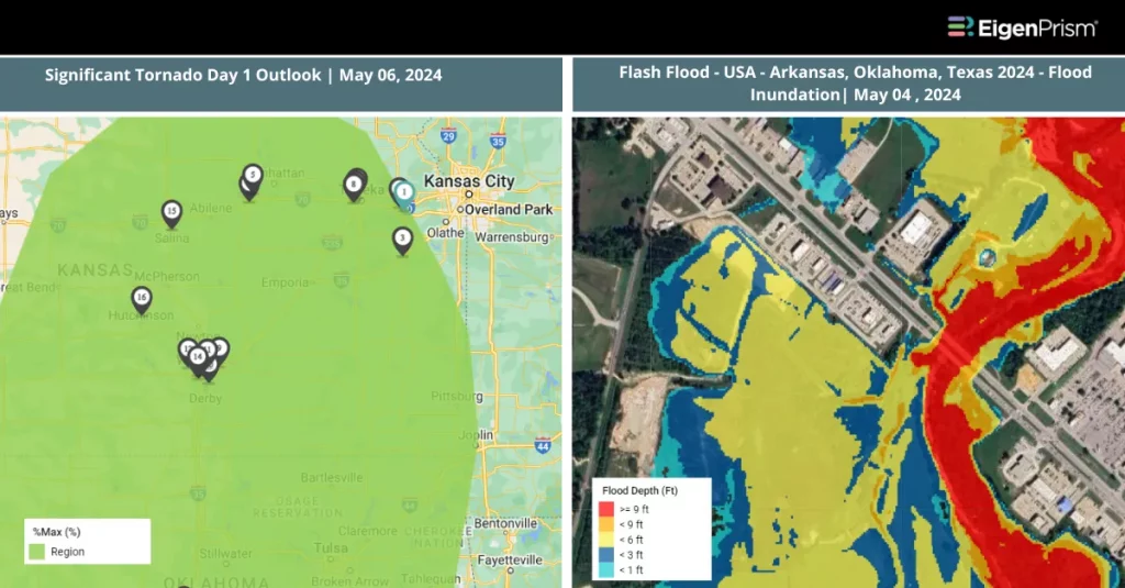
Flash Flood – USA Central (USA) Arkansas Oklahoma Texas 2024 – Flood Inundation as of 2024-05-05
Tornado & Hail
Subscribers of Canopy Weather in EigenPrism can assess the impact of the tornadoes and hail from May 04, 2024, using these footprints within EigenPrism®
US Tornado Proximity Map as of 2024-05-04
Daily CONUS Hail Swath Map –as of 2024-05-05
Forecast
All EigenPrism® users can assess the forecast of this multi-peril event using the following report template:
US Severe Weather 2024 Forecast Report
The report template auto-updates with the latest available footprints, which include:
- Significant Tornado Day 1 Outlook
- Significant Hail Day 1 Outlook
- Significant Wind Day 1 Outlook
- WPC 3-Day Excessive Rainfall Outlook
- NA 5-day Flood Potential
- NA 3-day Flood Potential
- US Flood Outlook
Escape the News Cycle | Get Notified Automatically for Events Impacting Your Assets
With EigenPrism Alerts, you can set Alerts and free yourself from constant event monitoring. Set up personalized alerts based on predefined impact thresholds and choose how you receive them – via email, SMS, or directly within EigenPrism. This way, you stay informed on your own terms, focusing only on the events that truly matter to your assets.
Set your alerts now.
Don’t have access to EigenPrism®?
Contact us if you want to learn more


