

Severe Weather Intensifies Across Southern US
Severe weather across the South has started getting intense with more rain and thunderstorms, stretching from Texas to Florida. On Friday, the storm’s intensity and reach will escalate as it moves eastward, bringing a broad threat of severe thunderstorms and extensive flooding from the southern Plains across to the Southeast.
Parts of Texas and Oklahoma may still experience the aftermath of Thursday’s severe storms into Friday morning, with a new wave of storms expected to erupt across Oklahoma, Texas, Arkansas, and Louisiana by early afternoon.
The potential for hail, damaging wind gusts, heavy downpours, and tornadoes is high, with possibility of a significant tornado threat spanning from Texas and Oklahoma to Alabama, Georgia, and Florida. Cities like Dallas, Little Rock, Arkansas, and Jackson, Mississippi, face a Level 2 out of 5 risk for severe thunderstorms on Friday, as forecasted by the Storm Prediction Center.
Atlanta may see an additional 3 to 4 inches of rain from Friday night into the early hours, heightening the risk of flash flooding due to the already saturated ground. By Saturday, the expansive storm will target much of the East with another round of severe thunderstorms and flooding.
In the North, freezing rains across the Great Lakes, extending to the Northeast by Saturday evening. This precipitation may shift to a mix of rain, ice, and snow in the higher terrains of the interior Northeast later that day.
Severe Weather Intensifies Across Southern US: Actionable Insights on EigenPrism
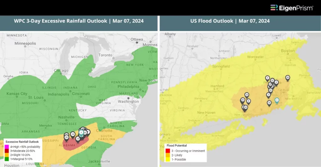
Forecast
All EigenPrism® users can assess the forecast of this multi-peril event using the following report templates:
US Severe Weather- Mar 2024 Forecast Report
The report template auto-updates with the latest available forecasts, which include:
- 72-hour Snow Accumulation
- WPC 3-Day Excessive Rainfall Outlook
- US Flood Outlook
- NA 5-day Flood Potential
- NA 3-day Flood Potential
- 72-Hr Forecast Freezing Rain Accumulation
- Daily Peak Wind Gust across North America
Mar 7 | Northeast to South on Alerts: Severe Weather Conditions Across US
 The United States is currently facing severe weather watches, warnings, and advisories, from heavy rains in the Northeast affecting the Interstate 95 corridor and disrupting the evening commute to the South’s anticipation of severe thunderstorms. The National Weather Service also forecasts rain, potentially heavy in localized areas, from the Southeast to New England. The Northeast is under a flood watch from New Jersey to Maine, affecting cities like New York and Boston with intensifying heavy rain. New England may see continued rainfall till Thursday.
The South is currently on alert for a severe weather event beginning Thursday, with storms expected from central Texas to western Oklahoma. By Friday, the system will move towards the east, affecting cities like New Orleans, Jackson, and Mobile, emphasizing the event’s extensive reach. Concerns include damaging winds, heavy rain, and the chance of tornadoes.
Southern Georgia, southeast Alabama, and northern Florida may experience severe storms early, with potential wind damage, hail, and tornadoes. The Carolinas might face severe storms by late afternoon. Additionally, heavy rainfall poses a flooding risk in the South, compounded by rainfall earlier in the week.
Severe Weather Conditions Across US: Actionable Insights on EigenPrism
Post-Event
Tornado
Subscribers of Canopy Weather can assess the impact of the tornadoes from March 05 – March 07, 2024 using this report template within EigenPrism®
US Tornado Proximity Map as 2024-02-06
Hail
24-hr Hail Reports ending as of 2024-03-06
Forecast
All EigenPrism® users can assess the forecast of this multi-peril event using the following report templates:
US Severe Weather- Mar 2024 Forecast Report
The report template auto-updates with the latest available forecasts, which include:
- 72-hour Snow Accumulation
- WPC 3-Day Excessive Rainfall Outlook
- 72-Hr Forecast Freezing Rain Accumulation
- Daily Peak Wind Gust across North America
- US Flood Outlook
Escape the News Cycle | Get Alerts Automatically For Events Impacting Your Assets
With EigenPrism Alerts, you can set Alerts and free yourself from constant event monitoring. Set up personalized alerts based on predefined impact thresholds and choose how you receive them – via email, SMS, or directly within EigenPrism. This way, you stay informed on your own terms, focusing only on the events that truly matter to your assets.
Set your alerts now.
Don’t have access to EigenPrism®?
Sign up for a trial account and access full impact reports of all events. Contact us, and we’ll set up a trial account for you.


