

Snow, Rain, and Wind to Sweep across the Northeast and Mid-Atlantic Region
As the weekend approaches, the anticipated winter storm in the Northeast and mid-Atlantic regions is shaping up to be a complex weather event, bringing snow, rain, and wind. The exact details of the snowfall forecast, particularly for areas near the I-95 corridor, remain uncertain due to variables like the storm’s future track, intensity, and the availability of cold air near the coast.
The disturbance that will spur the storm’s development in the East is moving from the Southwest toward the Central Plains as it intensifies and tracks northward up the East Coast. The storm is predicted to produce snow or a mix of rain and snow affecting regions from the Ohio Valley to parts of the Appalachians, mid-Atlantic, and Northeast by Saturday or Saturday night. Gusty winds are also expected in some areas.
By Sunday, the storm will begin to move away from the Northeast, but snow, rain, and wind will continue throughout the day. Significant snow accumulations are more likely just to the north and west of regions from Washington D.C to New York City, and parts of southern New England, including the Boston, Providence, and Hartford metro areas, may also see significant snow.
Snow, Rain, and Wind to Sweep across the Northeast and Mid-Atlantic Region: Actionable Insights on EigenPrism
All EigenPrism® users can assess the forecast using the following event footprints:
- 72-Hr Forecast Freezing Rain Accumulation (90th Percentile) as of 2024-01-04
- 72-Hr Forecast Snow Accumulation (90th Percentile) as of 2024-01-04
- WPC 3-Day Excessive Rainfall Outlook as of 2024-01-04
- 1-3 Day Potential Winter Storm Overall Impact as of 2024-01-04
Jan 3 | Imminent Storm Could Blanket Northeast and Mid-Atlantic in Snow
A weekend storm that has the potential to slam the Northeast and the mid-Atlantic region with its first decent snowfall in over two years may finally bring winter to the region. The storm’s exact impact is still uncertain, as it depends on its path and intensity and is currently far off the West Coast.
This storm is part of an active pattern associated with an El Niño winter, potentially leading to impactful snow in densely populated East Coast areas. In the South, it’s expected to bring beneficial rain to drought-affected areas like eastern Texas, Louisiana, and southern Mississippi.
Starting Thursday evening, rain is expected to set in over eastern Texas and gradually move eastward along the storm’s path, eventually encompassing the Southeast and portions of the mid-Atlantic. This weather system might lead to flooding concerns in the South, especially in regions already soaked by a separate wet system earlier in the week.
The key concern is whether precipitation will fall as snow or rain, particularly along the I-95 corridor stretching from Washington, DC, to Boston. An inch of snow in these areas would break nearly two-year-long snowless periods for several major cities. For instance, New York City has not seen an inch of snow on a single calendar day for nearly 700 days, with 2023 being the least snowy year on record for Central Park.
Imminent Storm Could Blanket Northeast and Mid-Atlantic in Snow: Actionable Insights on EigenPrism
All EigenPrism® users can assess the forecast using the following event footprints:
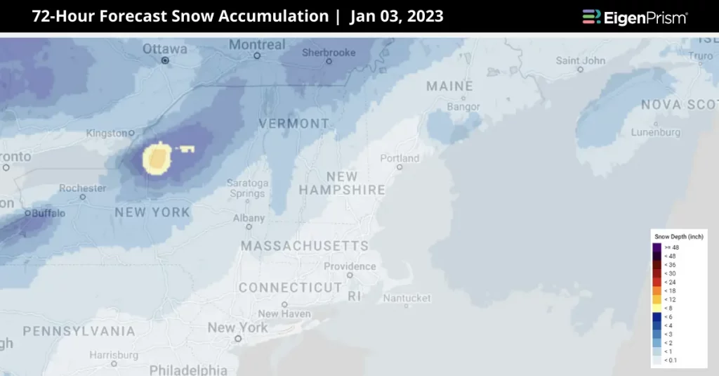
- 72-Hr Forecast Snow Accumulation (90th Percentile) as of 2024-01-03
- 1-3 Day Potential Winter Storm Overall Impact as of 2024-01-02
- North America 5-day Flood Potential as of 2024-01-02
Don’t have access to EigenPrism®?
Sign up for a trial account and access full impact reports of all events. Contact us and we’ll set up a trial account for you.


