

Intense Nor’easter Breaks Records, New York City Sees Snowiest Day in 2 Years
The Northeast United States has emerged from the most significant snowstorm in recent years, affecting areas from West Virginia to Massachusetts. This snowstorm resulted in school closures, widespread travel disruptions, and more than 1,500 flight cancellations across the region.
In New York City, Central Park recorded 3.2 inches of snow, marking the city’s highest single-day snowfall since January 2022. Despite lighter snowfall in downtown Philadelphia, the suburbs north and west of the city reported more than half a foot of snow, contrasting with minimal accumulations in Washington, D.C., and Baltimore.
As the Nor’easter accelerated off the coast, most winter alerts have expired, though gusty winds and lake-enhanced snow showers may continue to affect parts of upstate New York and northwest Pennsylvania. The storm has left more than 130,000 homes and businesses without power across the Northeast, with Pennsylvania bearing the brunt of the outages.
Intense Nor’easter Breaks Records, New York City Sees Snowiest Day in 2 Years: Actionable Insights on EigenPrism
Post-event
72-hour observed snow accumulation as of 2024-02-14
Forecast
All EigenPrism® users can assess the forecast of this event using the following report templates:
US Winter Storm Forecast Template
The report template auto-updates with the latest available forecasts, which include:
- 72-hr Forecast Freezing Rain Accumulation,
- 72-hr Forecast Snow Accumulation,
- Potential Winter Storm Overall Impact
Winter Severity Component Report Template
The report template auto-updates with the latest available forecasts. It consists of the summary level (Potential Overall Winter Storm Impact) and all six component WSSI datasets from NWS:
- Potential Snow Amount Impact
- Potential Snow Load Impact
- Potential Ground Blizzard Impact
- Potential Ice Accumulation Impact
- Potential Blowing Snow Impact
- Potential Winter Storm Flash Freeze Impact
Feb 13 | Major Snowstorm Forecasted for New York, Biggest in Two Years

The Northeast, including New York City, is bracing for the biggest snowstorm in two years, with forecast models indicating a significant winter storm that could impact the region from Philadelphia to Rhode Island. The storm has shifted southward, increasing the likelihood of substantial snowfall along the Interstate 95 corridor. The heaviest snowfall will potentially lead to significant travel delays as the rates of snowfall will reach up to 2 inches per hour.
Winter alerts are in place for 49 million people across the Central Plains, Midwest, Northeast, and New England. Snow will start in parts of eastern Oklahoma, and southern Missouri, and extend into Arkansas, western Tennessee, and southern Kentucky with freezing rain moving up through the mid-Atlantic into the Northeast.
For New York City, the heaviest snow is expected just north of the metro area. However, a slight southward shift in the storm’s path could increase snowfall in the city. CNN reports that authorities issued New York City’s first winter storm warning in over two years on Monday afternoon. Forecasters predict the city will receive 5 to 8 inches of snow, but even 2 inches would constitute the biggest storm since January 2022.
The storm will bring widespread snow of 3 to 6 inches across the Northeast and New England, with a narrow band receiving 6 to 12 inches of snow from northern New Jersey to eastern Massachusetts. Strong winds of 25 to 35 mph will further reduce visibility and exacerbate travel delays.
Snowstorm to Hit New York: Actionable Insights on EigenPrism
Forecast
Winter Storm
All EigenPrism® users can assess the forecast of this multi-peril event using the following report template :
US Winter Storm Forecast Report Template
The report template auto-updates with the latest available forecasts, which include:
- 72-hr Forecast Freezing Rain Accumulation,
- 72-hr Forecast Snow Accumulation,
- Potential Winter Storm Overall Impact, and
- Potential Winter Storm Flash Freeze Impact
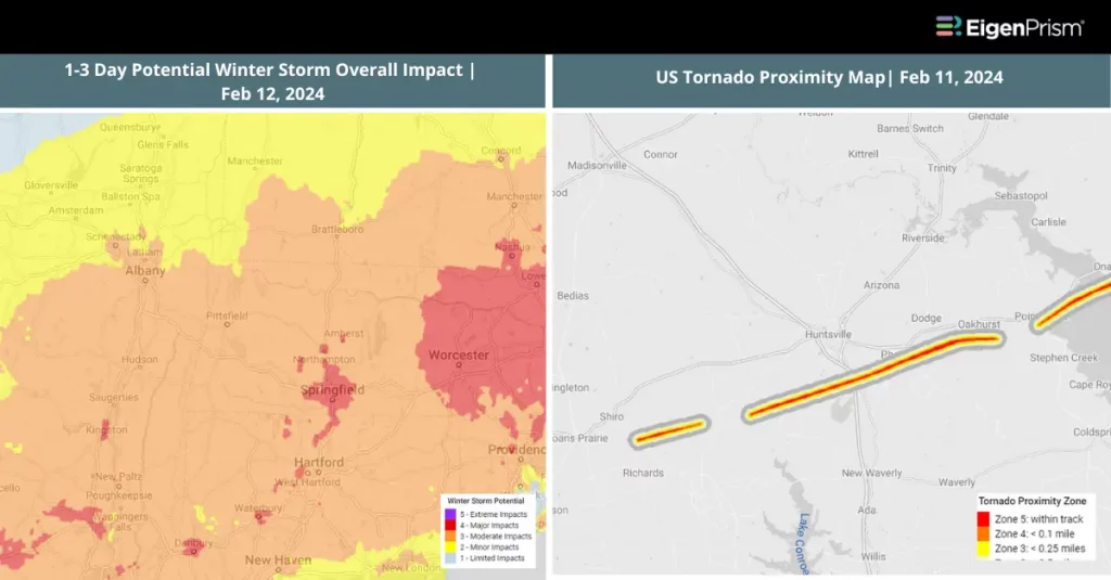
Feb 12 | Snow and Severe Thunderstorms Target the Northeast and Southeast US
 The United States is all set to experience severe weather thunderstorms capable of producing hail and tornadoes across the central Gulf Coast before moving toward the southeast. Apart from this, a significant snow event will sweep across the Northeast. About 23 million people from eastern Texas to western Georgia are at risk of this severe weather.
The National Weather Service warns of heavy rainfall across the Mid-South, which could lead to flash flooding due to training showers and thunderstorms. A level 1 out of 4 risk of excessive rainfall extends from Texas to North Carolina, with some areas expecting rainfall rates of up to 1 inch per hour.
A tornado watch is in effect for parts of Louisiana and Mississippi until Sunday evening, with the potential for tornadoes, 70 mph damaging winds, and hail as large as 1.75-2.5 inches in diameter. The Storm Prediction Center anticipates scattered supercell development, capable of producing strong tornadoes and large hail.
CNN weather states that as the severe weather risk moves into Georgia and the Carolinas, the Northeast braces for a snowmaker that could deliver up to a foot of snow by Tuesday. This winter storm, originating from the Rockies and moving through the Ohio River Valley, will cause heavy snow and possible travel disruptions across the Northeast, affecting about 20 million people under winter storm warnings or watches.
Snow and Severe Thunderstorms Target the Northeast and Southeast US: Actionable Insights on EigenPrism
Post Event
Subscribers of Canopy Weather can assess the impact of the tornadoes using this report template within EigenPrism®
US Tornado proximity map as of 2024-02-11
Forecast
Winter Storm
All EigenPrism® users can assess the forecast of this multi-peril event using the following report template :
US Winter Storm Forecast Report– Template
The report template auto-updates with the latest available forecasts, which include:
- Potential Winter Storm Overall Impact,
- Potential Winter Storm Flash Freeze,
- 72-Hr Forecast Snow Accumulation (90th Percentile),
- 72-Hr Forecast Freezing Rain Accumulation (90th Percentile),
- Significant Tornado Day 1 Outlook,
- Significant Hail Day 1 Outlook,
- WPC 3-Day Excessive Rainfall Outlook,
- US Flood Outlook,
- NA 5-day Flood Potential, and
- Significant Wind Day 1 Outlook
- WPC 3-Day Excessive Rainfall Outlook,
- US Flood Outlook,
- NA 5-day Flood Potential, and
- Significant Wind Day 1 Outlook
Escape the News Cycle | Get Alerts Automatically For Events Impacting Your Assets
With EigenPrism Alerts, you can set Alerts and free yourself from constant event monitoring. Set up personalized alerts based on predefined impact thresholds and choose how you receive them – via email, SMS, or directly within EigenPrism. This way, you stay informed on your own terms, focusing only on the events that truly matter to your assets.
Set your alerts now.
Don’t have access to EigenPrism®?
Sign up for a trial account and access full impact reports of all events. Contact us, and we’ll set up a trial account for you.


