

4 Years Since Hurricane Michael, the first Cat 5 hurricane to hit the Florida Panhandle
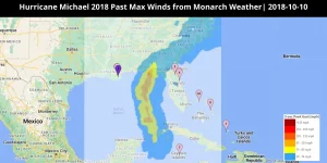
On October 10, 2018, Michael became the first hurricane to land in the Florida Panhandle as a Category 5 hurricane. According to CNN, it was reported to have 160 mph peak winds. It is still considered the strongest storm to make US landfall since Hurricane Andrew in 1992.
Mexico Beach and Panama City along the Florida Panhandle experienced the harshest effects of Hurricane Michael. In Cuba, over 200,000 people faced power outages due to the hurricane’s gusts as it moved to the west of the island.
Michael’s storm surge was 9–14 feet above ground level. The destruction was unprecedented where Michael’s wind and storm surge practically erased Mexico Beach and sections of Panama City off the map.
A national response plan was implemented throughout Cuba and Florida. The plan included evacuation in phases and a declaration of a hurricane emergency. A state of emergency was also declared in more than 92 counties and a committee of 500 national guard members was activated. However, despite all the measures the damage from Hurricane Michael was catastrophic.
Hurricane Michael caused $25.1 billion (2018 USD) in economic damage. This damage includes $100 million in economic losses in Central America and $6 billion in estimated replacement costs for damaged American fighter jets at Tyndall Air Force Base. Insurance claims of approximately $6.23 billion were made in the United States.
ACTIONABLE ANALYTICS ON EIGENPRISM®
Customized and Mobile-Enabled Event Alerts: EigenPrism® allows users to set alert notifications with custom thresholds which helps in reducing the noise and producing targeted actionable analytics. EigenAlert feature provides automated notifications with key metrics to estimate impact, which are updated as forecasts and advisories change. To set up event alerts, visit our help center.
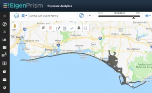
Access NOAA’s Remote Sensing Imagery for Hurricane Michael on EigenPrism®:
 Login to EigenPrism® and select the appropriate exposure for your analysis.
- Hover over the Event Catalog icon, then click on the WMS Layer Overlay icon when it appears in the drop-down:
- Type “Hurricane Michael” in the search box, select the option that appears and click Go.
- The imagery layers** will appear in the drop-down; select an individual layer or multi-select, and the images will be overlaid on your exposures.
- You can now zoom in to any location of interest and assess the imagery.
- Turn on the “in map view” option to investigate assets within the zoomed area on the map:
NOAA’s satellite imagery from Hurricane Michael is available on EigenPrism®:
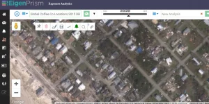
Assessing the impact
EigenPrism users can overlay the following Hurricane Michael footprint on their exposure:
For subscribers of KatRisk and reask, real-time hurricane footprints on EigenPrism® are available for analysis.
Don’t have access to EigenPrism®?
Sign up for a trial account and access full impact reports of all events. Contact us and we’ll set up a trial account for you.


