

Intense Bursts of Rains Threaten Los Angeles with Floods and Landslides
California is facing what looks like its final round of rainfall from a series of storms that have caused significant disruptions across the state. Los Angeles and other parts of Southern California are facing the most substantial risk of flooding and landslides due to these conditions.
Over 35 million people are under flood alerts as rain continues to drench California, particularly focusing on Los Angeles and coastal Southern California. Flood watches are in effect across the state. Downtown Los Angeles is on the brink of experiencing its wettest February on record if it receives just over 2 inches more rain. This month is already Santa Barbara’s second-wettest February on record.
Winter weather alerts are in effect for the Sierra Nevada, with up to 5 feet of snow expected in some areas by Wednesday night. High-elevation areas are anticipating widespread snowfall of 1-2 feet. As California faces this deluge, the saturated ground and swollen waterways are struggling to absorb the influx of water, leading to runoff that threatens local roads and raises the risk of mudslides and widespread flooding.
The atmospheric river fueling these storms is expected to weaken, but isolated downpours remain a concern, particularly as they target different parts of coastal Southern California, raising rainfall totals and the flood threat.
Intense Bursts of Rains Threaten Los Angeles with Floods and Landslides: Actionable Insights on EigenPrism
Post-event
All EigenPrism® users can assess the post-event impact of the snow accumulation using the following event footprint:
72-hour observed snow accumulation as of 2024-02-21
Forecast
All EigenPrism® users can assess the forecast of this multi-peril event using the following report template:
California Atmospheric River Feb 2024 Forecast Report
The report template auto-updates with the latest available forecasts, which include:
- WPC 3-Day Excessive Rainfall Outlook from NWS,
- US Flood Outlook from NWS,
- North America 3-day Flood Potential from Adiabat,
- North America 5-day Flood Potential from Adiabat,
- Landslide Potential,
- 72-hr Forecast Freezing Rain Accumulation,
- 72-hr Forecast Snow Accumulation, and
- Potential Winter Storm Overall Impact
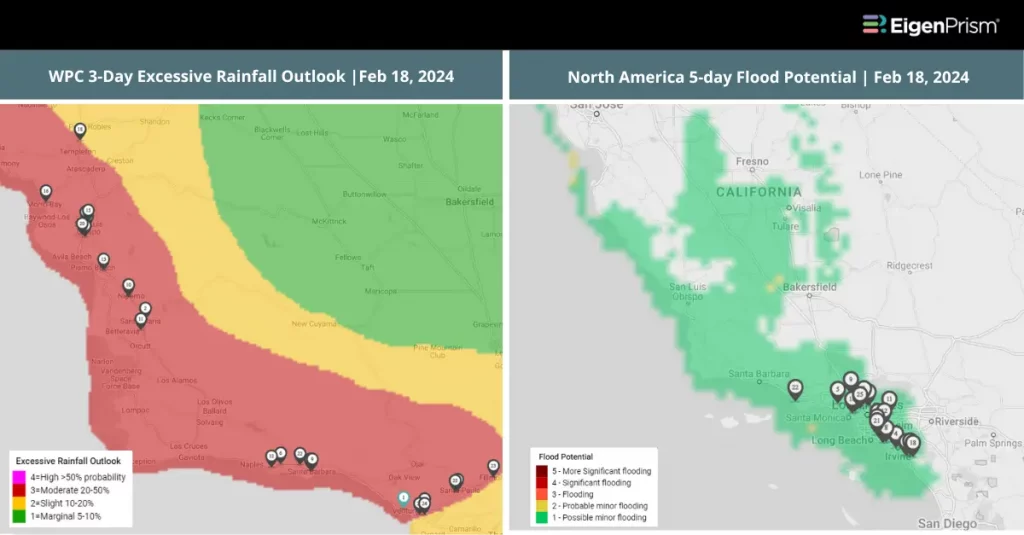
Feb 20 | California Under Flood Alerts Due to New Atmospheric River
With nearly the entire population of California under flood alerts, officials are urging caution, emphasizing the dangers of flooding and landslides that could arise from the current conditions. The latest storm has shifted its focus to Southern California, particularly affecting the greater Los Angeles area with heavy rainfall.
This shift comes after Santa Barbara and Ventura counties experienced the initial brunt of the storm, which has now moved on, leaving behind a trail of potential hazards. The storm has already led to tangible disruptions, including the closure of Santa Barbara Airport due to significant flooding. Across the state, numerous reports of flooding, rock, and debris obstructing roads have emerged, highlighting the storm’s capacity to disrupt daily life and transportation.
The storm has triggered flash flood warnings in Santa Barbara and Ventura counties, with 2 to 5 inches of rain drenching the area and higher elevations receiving up to 9 inches. Downtown Los Angeles could see between 2 and 3 inches of rainfall, adding to the historic totals recorded earlier in the month. California’s Sacramento Valley faces a rare severe weather risk, the first since February 2015. The forecast includes the potential for severe thunderstorms that could bring damaging wind gusts, hail, and even brief tornadoes, further exacerbating the state’s challenges.
California Under Flood Alerts: Actionable Insights on EigenPrism
Post-event
All EigenPrism® users can assess the post-event impact of the snow accumulation using the following event footprint:
72-hour observed snow accumulation as of 2024-02-20
Forecast
All EigenPrism® users can assess the forecast of this multi-peril event using the following report template:
California Atmospheric River Feb 2024 Forecast Report
The report template auto-updates with the latest available forecasts, which include:
- WPC 3-Day Excessive Rainfall Outlook from NWS,
- US Flood Outlook from NWS,
- North America 3-day Flood Potential from Adiabat,
- North America 5-day Flood Potential from Adiabat,
- Landslide Potential,
- 72-hr Forecast Freezing Rain Accumulation,
- 72-hr Forecast Snow Accumulation, and
- Potential Winter Storm Overall Impact
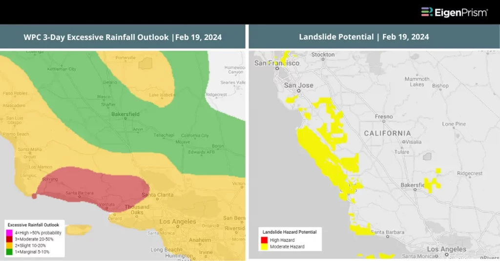
Feb 19 | California Faces Flood Risks from Another Approaching Atmospheric River
 California is preparing for the arrival of another atmospheric river, with residents across the state on high alert. This powerful weather system will sweep across the Golden State, bringing the threat of heavy rainfall, strong winds, and significant snowfall. Nearly 37 million Californians, spanning the coast from Redding to San Diego, are under a flood watch. This atmospheric river follows a recent storm that drenched central California, setting the stage for what could be a challenging week ahead.
The National Weather Service has issued warnings, emphasizing the risk of widespread flooding, landslides, and other storm-related hazards. Residents are advised to avoid flooded roadways and prepare their properties for flooding, with warnings of possible large mud or rockslides on canyon roads and debris flows in areas recently affected by wildfires.
The flood watch covers different cities, including San Francisco, Monterey, Chico, Fresno, Santa Barbara, Los Angeles, Temecula, and San Diego. Rainfall predictions for the lower elevations range from 2 to 5 inches, with isolated areas in the Santa Lucias and Santa Ynez ranges possibly receiving up to 10 inches. Santa Barbara County faces the highest threat of flash flooding.
A winter storm warning is also in effect, with the eastern Sierra expecting 3 to 5 feet of snow at altitudes above 9,000 feet and wind gusts reaching 50 mph. The San Gabriel Mountains could receive several feet of snow, affecting areas like Big Bear Lake with up to 8 inches of snow. Gusty winds will complicate travel in these snowy regions.
California Faces Flood Risks from Another Atmospheric River: Actionable Insights on EigenPrism
All EigenPrism® users can assess the forecast of this multi – peril event using the following report template:
California Atmospheric River Feb 2024 Forecast Report
The report template auto-updates with the latest available forecasts, which include:
- WPC 3-Day Excessive Rainfall Outlook from NWS,
- US Flood Outlook from NWS,
- North America 3-day Flood Potential from Adiabat,
- North America 5-day Flood Potential from Adiabat,
- Landslide Potential,
- 72-hr Forecast Freezing Rain Accumulation,
- 72-hr Forecast Snow Accumulation, and
- Potential Winter Storm Overall Impact
Escape the News Cycle | Get Alerts Automatically For Events Impacting Your Assets
With EigenPrism Alerts, you can set Alerts and free yourself from constant event monitoring. Set up personalized alerts based on predefined impact thresholds and choose how you receive them – via email, SMS, or directly within EigenPrism. This way, you stay informed on your own terms, focusing only on the events that truly matter to your assets.
Set your alerts now.
Don’t have access to EigenPrism®?
Sign up for a trial account and access full impact reports of all events. Contact us, and we’ll set up a trial account for you.


